The Knitting Nurse

Rambles and Travels


Leave a comment

A Winter’s Walk

I’m having a bit of a glum morning. Though I try to not let it drag me down the state of the world and the dysfunctional #$*’s in US politics has been magnifying everyday troubles and annoyances more than usual.

My cat Jane gazed at me two days ago with a completely clouded over left eye. Having impaired sight in her rt eye from a chronic infection, she is now nearly blind, walking into things.  We see the vet this AM. I hope this is a simple infection that can be treated.  It’s hard having a geriatric pet. Some days they look a bit stiffer or don’t eat very well – a reminder of their shortening lease on life.

A walk in a local park Thursday was just the ticket to lift the spirits.

Low tide was still high enough to make the beach route impassable.  A seal kept an eye on us like a para scope.  The clouds washed the sea in the prettiest grey-green.

Up the trail into the Madrones and young fir we walked.  It was very windy – the trees swayed.

Madrones – A favorite tree of mine – sculpted and sinuous.

I like how their curved lines wend around the arrow-straight fir.

There’s a coffee shop at Fort Worden we took full advantage of. Returning the way we came the sun made an appearance.  Hooray! Incredible how the color of the water changed so quickly and dramatically, now a deep blue.

The daylight lengthens. Tuesday it was warm enough to garden all day. A gift!

More later-


Leave a comment

Balanced Stones on the Beach

A sunset walk on the beach worked wonders to soothe my eyes after a day of computer work for school. North Beach, here in town, is a fine place for just that. I started at about 6 o’clock.

Just a hint of a warm glow washed the bluffs and sand.

The sinking sun washed Mt. Baker in a painterly way.

Have you seen a Pacific sunset?

Walking back I noticed something I couldn’t believe I’d missed. Balanced stones, seemingly someone’s calling card, were everywhere.  The glare of the setting sun must have hid them while walking west.

A lesson to be learned?  One may miss the details if looking in one direction only?


Leave a comment

Rialto Beach – Knitting, Napping, Beach-combing.

In early July my friend Olivia arrived for a music festival. We took a trip out to the west coast to camp and explore Rialto Beach. I hadn’t been in ages. Pretty crispy, I was ready for a trip. The agenda was simple-with R&R the main goal-involving beach combing, knitting and napping.

Both days were warm and grey but still requiring sleeves and a light windbreaker. I loved it. Sometimes I need that gray slate to rest my eyes on and relax.

It’s a beautiful beach. On the north side of the mouth of the Quillayute river, La Push is on the opposite side. One mile up the beach is the Hole in the Wall formation, a natural arch. Seastacks sit offshore.  The Olympic Peninsula has a wild and rugged coast.

img_0347

Our first evening there involved naps and knitting.

Ever nap on the beach? It’s divine, as Olivia demonstrates. See her nose peeking out?

IMG_0358

My Orbit shawl’s simplicity fit the bill. One skein of DK or worsted yields a long swath of garter-squish for the neck. I love it. It’s destined to be an old stand-by for gifts and special, single skeins. It could also be knit up in other gauges. You just knit ’till you run out of yarn.

img_0353

Finished the next day:

img_0379

We had a good giggle at our knit goods photo sessions. Olivia worked her shawl into pretty poses. You can’t see it. It’s in TML in a pale green the color of the water behind it.

img_0359

img_0364

The Hole in the Wall formation is about a mile walk up the beach. There are tide-pools galore.

IMG_0359

More shallow pools are on the other side of the arch.

img_0403

You can see how the coastline once stretched out, remnants remain.

img_0390

There were plenty of critters to observe.

Vivid, lime-green anemones:

img_0422

The ONLY sea star I saw:

img_0413

A crab met its demise in an anemone:

img_0429

Mussels with wee barnacles growing on them:

Goose barnacles. I have a hunch these are Pelagic Goose barnacles which began life living afloat in rafts in the open ocean, these now stranded on the beach.

Remnants of a squid (?or octopus?), closely watched from above by a group of noisy eagles.

There were remains of what I suspect was a huge fish of some sorts. The bones were quite soft and flexible. This one looked like a pelvis.

This a snout (do they call those beaks on fish/)

Vertebrae? For scale, this was long, maybe 3+ feet.

A fault line on the archway shows great detail of uplift, classic for this edge of the continent that is being thrust upward by the Pacific Plate.

img_0417

The rocks are just beautiful out here – the colors calm yet defined.

I’ve missed my friend Olivia. What a treat to have some quality time with her, camping, walking, exploring.  This winter I plan to return to this area during off-peak time when the weather is  wintery.


Leave a comment

Low Tide Amble

These pics turned out so pretty, I just had to share.

A very low tide begged for a beach walk the other day.

It was cold. Note Pete has a sweater on? That means it’s cool’ish in his book. I needed a puff jacked and my Northmavine Hap shawl a sweet friend made and mailed to me. The colors reminded her of a blustery winter day on a WA beach and she couldn’t have been more spot on.  A habitat hat I knit of Swans Island All American Worsted (in love with it) and Pete’s Windschief in Lamb’s Pride worsted provided wooly warmth.

The North  Cascades barely show behind Point Wilson.

The tide pools with really unusual critters tent to be further west on the peninsula.

Regardless, we found some sea stars.

Crabs

Chiton:

Anemones and barnacles sharing real estate:

Opened, they have such vivid colors, a contrast to the day’s gray.

Low tides are a treat!


Leave a comment

Hawaii – Part 2 of ? – Volcanoes National Park – Glowing gasses and lunar landscapes.

Let’s travel back to Hawai’i. It’s March. And Pete and I are in search of sun and new terrain to explore.  After hanging out in Kona, we head to Hilo via Hawai’i Volcanoes National Park.

The first day started with an outstanding meal at the Volcano House. We ate there twice. With a view over the Kilauea Caldera, the Halema’uma’u Crater venting, it was my first glimpse into an active volcanic process.  Wait…I’ve been to Yellowstone NP.   The Hawaiian chain was created by volcanoes which con’t to add land mass in a more fluid, less explosive manner than what we commonly associate with volcanoes. In this park, 70 million years of activity are showcased. It was fascinating. The visitors center is packed with learning.

We chose the Destruction Trail hike that day.  From it’s start, there’s an overlook into the Kilauea Iki Crater. A popular day hike, the Kilauea Iki Trail passes through the crater below. The last violent eruption of the Kilauea crater occurred in 1959.  Lava filled to the demarcation of brown and green you see on the opposite wall.

img_8516

Our trail set off through forest, thick and gnarled, twisted while lush at the same time. This trail is wheelchair accessible.

img_8521

Pre-historic looking vegetation abounds.

img_8530

img_8531


img_8584

The trail pops you out into this lunar landscape. It’s breathtaking.

img_8527

Pu’u Pua’i is the cinder cone in the background. It formed with the 1959 eruption. The crater above, for reference, is tucked down behind the cone in this photo.

The view is dry and sparse. Bits of vegetation slowly grow. I found it quite beautiful.

img_8545

Many sunken spots pock the land. Our knowledgeable friend and natuaralist explained to me the land continues to shift and change.

This is the Ōhelo berry and plant.  Related to the cranberry, they are edible but protected in this park, being the food for the beloved Nene Goose.  I thought the color against the cinders striking.

Our walk took us to the start of Byron’s Ledge Trail. It was stunning! We parked ourselves here and drank in the sounds, sights and smells.

img_8548

There’s just no way to capture all that in a photo so I’ve uploaded a video I took, a meager substitute.

I’m not knowledgeable on taking video and making it look great. Imagine the birdsong magnified so it completely fills the space, several times louder than you hear, almost deafening.   We gaped. And listened. And enjoyed.

A real treat, Ohi’a lehua flower buds and blooms up close:

img_8560

The blooms’ nectar feeds the Crimson honeycreeper.  Check out this page for some fun facts about the plant and some photos of it’s aerial roots (which don’t reach the ground but collect moisture from the air).

This pretty little plant I cannot find information about.

My mind spun at the foreign nature of the land and the flora.

Later that night we returned and saw the park at night. The gasses from the first photo in this post glowed in the dark. Some lucky visitors see lava. On this night, no lava percolated out.  But still, what a thrill!

img_8610 img_8609

I’d spend a whole week at this park next visit.

Next leg of the trip, into Hilo.


1 Comment

Hawaii! Part One of ? – Kona-The dry side. Boy they aren’t kidding.

We recently escaped WA’s winter for Hawaii. On day number one, I stumbled out to bright, sunny warmth and brilliant flowers.

Hibiscus and Bougainvillea.  How I’ve missed them! I used to grow both on my CA balcony.  So lovely! Someday I’d like a sun room that allows for growing such at home.


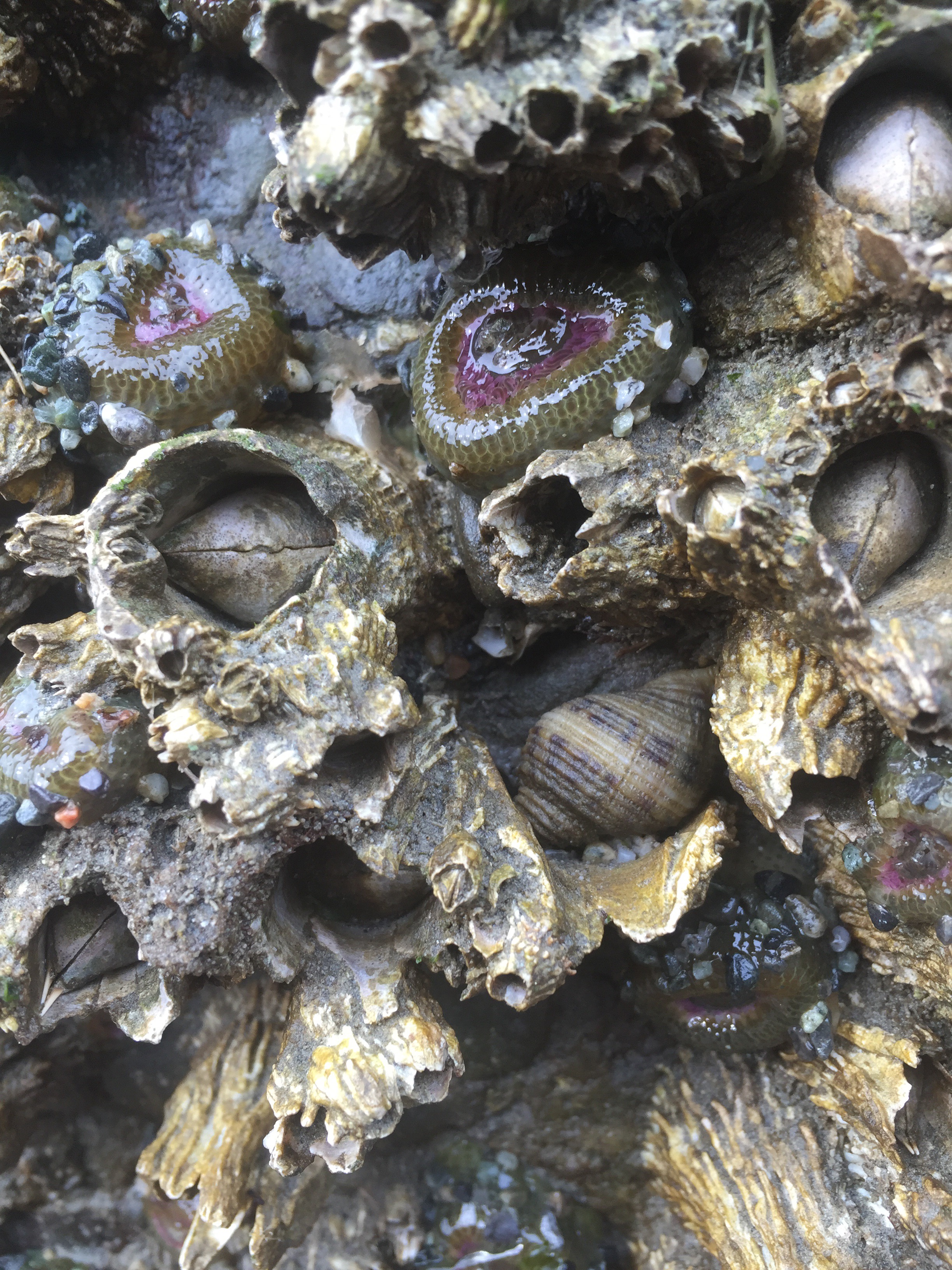
The tail end of winter made for big swell. This stirred up the water for unsafe swimming in some locations as well as poor snorkeling visibility. We did find swimmable spots.  Pete, an experienced and brave snorkeler swam farther out and saw oodles of colorful fish.

Plunk me in front of the ocean,anywhere, and I’m happy. Here, my first ocean view that morning.

After a reunion with a friend of Pete’s we headed south to Kealakekua Bay where we’d stay the next couple nights at the most comfortable Air B and B accommodation I’ve found to date.   It’s called the Plumeria Cottage.

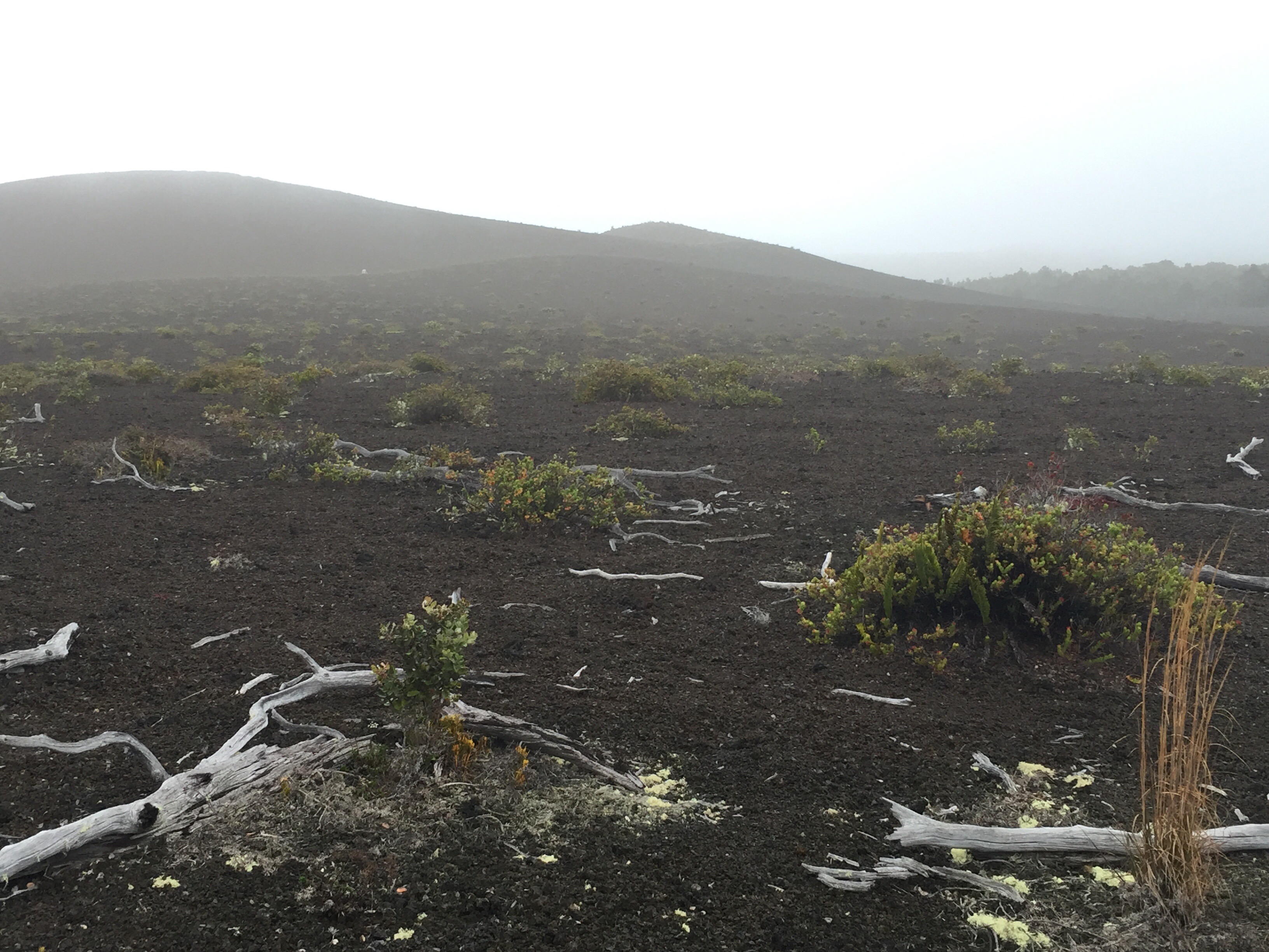
This is the dry side of the island. And they aren’t kidding. In some places old  lava flows sent brown, porous lava rock in jumbled piles and streams clear down to the ocean. Though the trees are lushly green, you can tell this is a  dry climate.

This bay is famous for having The Captain Cook monument on the far side of the photo below, where he met his demise. It can be reached by a steep hike or a KAYAK across the bay. Because of it being a haven for dolphins, access is limited. We enjoyed it from the shore.

The cottage was just up the road from Painted Church Road. This is a lovely, narrow road on the hillside above the bay. Organic produce and coffee Farms line the way. It reminded me a lot of the quiet, narrow roads in New Mexico that follow creeks and pass tiny towns.

One stop on this road is the Painted Church. The linked website gives much history and explanation of the paintings inside.  If you travel there, I recommend a stop.

It’s a beautiful structure. Hand-painted, folksy art adorns the walls and ceiling.
  

A cemetery, dry and rocky in places has pockets of  unusual flora both native and introduced. We enjoyed strolling about and looking at the unfamilliar plants.


Up on the highway, there are produce stands. The South Kona Fruit Stand specialized in fruit and smoothie drinks which were tasty.  I bought delicious small tangerines that rivaled anything I’ve ever had that came from CA.

In search of a beach  we went to Pu’uhonua O Honaunau National Historic Park.  This is called “Place of Refuge.”  From their website, “In old Hawaii, if you had broken a law, the penalty was death. Perhaps you had entered into an area that was reserved for only the chiefs, or had eaten forbidden foods. Laws, or kapu, governed every aspect of Hawaiian society. The penalty for breaking these laws was certain death. Your only option for survival is to elude your pursuers and reach the nearest puuhonua, or place of refuge.”

This was that place.

A high swell warning had park staff close off the immediate waterfront. We found a shady spot and listened  to the pounding waves for a while.  It was beautiful to see the folds and swirls of lava rock meet the pale, gritty sand.

IMG_8417

IMG_8416

This is a park of much a store called significance. There were lava rock partial walls  towards the end of the beach.

This is the dry side of the island. And people aren’t kidding when they say it’s dry. Here, lava flows have reached for or met the sea on many occasions. I enjoyed looking for flow patterns in the rocks along the beach.

IMG_8430

Coconut palms. Wouldn’t be a trip to somewhere warm without coconut palms.


Peter fit some snorkeling in that evening. I held off for Calmer  waters as I am a total newbie to snorkeling.

The next day we headed away from this neck of the woods for part two of the trip, en route to Volcano national Park and Hilo.


Leave a comment

Orcas Island-Day One-The Journey

Pete’s son Zac came up from FL last week. Wanting to share an adventure with him, and show him a beautiful part of WA, I planned a trip to Orcas Island.

We set off from Anacortes. It’s a beautiful sailing through a watery world.

IMG_8021

Orcas Island looks like two saddlebags.  53 square miles of

Orcas Landing welcomes the ferry.

Realizing some blog readers may have never set foot on a ferry I figured I’d include a photo of one. This one is landing to receive off-island traffic.

IMG_8122

Once we disembarked, with a bit of time until we could check into our lodging, we explored Deer Harbor.  The slow season, the harbor was quiet.

IMG_8026

At low tide, there were some critters to check out.

The VRBO cottage, the Dragonfly Cottage at Dragonfly Farm was adorable and comfortable.   It felt like a hobbit home. It backs up to Turtleback Preserve where we hiked the next day.

The property has a view across a valley of farms.  The Orcas landscape is patched with farms, thick woods and coastline.

An evening light, blurry photo looking across the valley.

IMG_8045

A pond with kayaks beckoned but I did not know they were up for use.

Three hens entertained me.

Spring is starting!

IMG_8143

So cozy. So comfy. This cottage was a great find. The next day, a hike among old oaks.


1 Comment

Fort Flagler – Beach Sights – A Hike Finished with a Sunset

I’ve let life’s busywork get between me and my hiking boots far too much this winter.

There’s nothing like a long, quiet walk to clear out the clutter.

Fort Flagler, on Marrowstone Island, is often empty mid-week, the case this day.

I started down by the light house which now houses a Fish and Wildlife Office. This watery passage shuttles large and small ships from Seattle and south out to the ocean.

IMG_7703

The tide was low. I skirted around Marrowstone point and followed the beach. The dark landform to the left is the tip of the Quimper Peninsula, home of Port Townsend, specifically Fort Worden and Point Wilson.  The sandy bluffs to the right are part of Whidby Island.

IMG_7708

Here’s a close view of the Fort and Point Wilson. The pics I snapped of town just didn’t turn out.

IMG_7752

It was a grey day, a “soft” day as I’ve heard such called.  This flat light made bright objects glow.

Madrona, its wood bright orange.

IMG_7727

A crab shell, purple and orange.

IMG_7716


IMG_7714

Green kelp.

IMG_7746

Manmade objects, some trash, some are relics of the military occupation of this point. Some trash I marvel at, such as this old engine.

IMG_7748

Not sure what this was but see the well defined rings? They are bright, shiny metal. Copper?

IMG_7744

I marvel at the color of PNW rocks, wet rocks, green, pink, red.

IMG_7730IMG_7764

Awwww!

IMG_7760

At the end of the beach there’s a view of the Olympic Mountains. Today they were buried in clouds.  Up the road a short distance led me into the woods.  Deep into the trees I went.

IMG_7774

Tiny water beads on this plant intrigued me.

IMG_7773

An unusually warm winter we’re having. Things are blooming, including this little guy.

IMG_7780

And the icing on the cake, above my starting point, sunset painted the clouds and water  pink and yellow.

IMG_7783

A marshy area abuts the lighthouse and research station below. I hoped to see birds. None showed.

IMG_7800

The evening sky was just stunning. Here’s the old lighthouse point my hike started at.

IMG_7791


Leave a comment

Frosty AM AND A sunny Walk

A hard frost iced up my garden for the first time Saturday morning.
This hardy kale shook it off and said, “Is that all you’ve got?  Bring it on!”

IMG_7218

Pretty!

The sun came out and melted all of that away. I met a friend at the farmers market for coffee, some shopping and a walk in local Fort Worden State Park. Check out the aerial photo on the link’s page. Here, one can take in views galore.

A meadow by the lagoon leads to North Beach.

Across the Strait lie the San Juan Islands.

Mt. Bakers looms behind the pretty lighthouse.

Crystal clear, Baker and the Cascades poke up behind Whidbey Island.

Marine trafic headed for Puget Sound and the Keystone ferry:

In this park, one can stroll along bluffs, the beach or under large, bright green foliage.  It was a glorious day!


1 Comment

Winter Walking – Pre-Snow – In Fort Worden

A friend from way-back visited over Thanksgiving.  The bone-chilling cold and snow thankfully arrived the day of his departure and not earlier.  A walk on the beach and in the trees was on his request list.  A trip to local Fort Worden State Park we took.

Starting on the beach we wound around Point Wilson and its sea-wall, past the lighthouse.

IMG_3556


That might be Mount Constitution on Orcas Island in the middle of the photo below, behind the red buoy.  Not sure.  I’m guessing. Thick clouds gave way to a sliver of light on the horizon. It was beautiful.

IMG_3563


The tide was too high for my usual full loop down to North Beach, up over the bluff and back.

IMG_3557


I’ve noticed gray days make an excellent foil for bright colors such as these rose hips.

IMG_3564


It rained buckets that AM, nixing our plans to visit the high mountains.  The clouds held off and allowed us a precip-free walk.

IMG_3567


IMG_3568

Up top, the old forts’ buildings spread out below.  The point in front is Hudson Point. Around its corner is Port Townsend Bay and the town itself.  Mystery Bay is the the bay straight ahead separating Indian Island and Marrowstone Island.

IMG_3572


So many lovely hiking trails so close to home.