The Knitting Nurse

Rambles and Travels


Leave a comment

Munro’s Bookstore in Victoria, B.C. – Quilted Artwork by Carole Sabiston

Moving day is one week tomorrow. Pete and I have been painting the new house’s interior like mad, hoping to complete most all before moving day.  In case you’re new to this blog, I just bought my first house.  I’m tired.  Really tired.  All extra energy goes towards preparing to move.  He’s a saint.  I’m grateful for his help and tolerating my occasional veering away from my typical cool and calm self to Nervous Nellie.  So much to do!  Not to mention work.

I miss my blog.

Thought I’d share something simple today, pics from a trip into Victoria when my mom and dad were here.  After we parted ways, I had a bit of time waiting for the ferry,  so I popped into Munros Books.  It’s a bucket list bookstore.

The inner harbor, looking away from the Parliament Building, from the ferry I arrived on.


IMG_3005

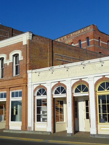
Gorgeous, eh?  The neo-classical building was designed for the Royal Bank of Canada in 1909.

The coffered ceiling is 24′ tall.  The space is light and bright.  Their website reports they’ve won two heritage awards for its renovation.


IMG_2995


A welcomed surprise, artful quilted wallhangings grace the arched walls inside.


The owner, Jim Munro’s wife Carole Sabiston is the artist who created the four hangings representing the The Four Seasons.  In the back are other pieces inspired by literature classics.

Timely, and my favorite season, fall:

IMG_2999


Winter:

IMG_3001


Spring:

IMG_2997


Summer:

IMG_2998


To see more of Carole’s works, which are hung in the store, visit the About Us page on Munro’s website. At the bottom, photos cycle through.

I cannot find a website for Carole.  Munro’s website states she works on theatre sets and costumes. She’s done commissioned works in many provinces as well as the UK and the US.  She uses hand and machine stitching.

How I’d love to see her studio!

Speaking of studios, I can’t wait to set up and USE my new sewing room.  It’s quite a bit smaller than the one I’ve had the last year but I have strategies to conserve space.  I’ll share all that later.

First I have to survive the painting, packing, moving and unpacking.


Leave a comment

Pacific Northwest Part 9 of 9 – West Coast of Vancouver – Tidepools and Trees on Steroids

It’s wild out there, the west coast of Vancouver I refer to.  Road #14 I took from Victoria, following the Strait of Juan de Fuca.  Scant gravel roads cross the island to the west coast.   Numerous Provincial Parks protect the island.

French Beach Prov. Park was my first campsite that portion of the trip. Let me tell ya, the Provincial Parks are carefully maintained, campsites are clean, fees are reasonable. It’s clear they invest in their parks and folks treat them well.  Wish the US could be as such.  Volunteering for CA state parks, lately, I see how badly they are abused.  It’s a shame how people abuse the outdoors.

But that’s a soapbox for another time.

A rocky stretch of French Beach I explored that evening.  Vastly different from the CA coast I’m used to, thick trees hug the coast.

Next day I played at Juan de Fuca Provincial Park.  Hiking a loop that took me to a couple of beaches, thick, primeval-looking trees  loomed over the trails.  A grey, muggy, moody day I enjoyed the neon-green contrast of the plants with the water/sky and rocks.

Thick, lush vegetation and gigantic trees along the trail:

Water was everywhere! Such a contrast from CA this time of the year. (A dry winter we had.)

Entertaining tide-pools I found here at Botany Bay.

This educational sign made me smile. Tidepools are fragile!  Some etiquette:

  • LOOK only.  Don’t touch!  Putting your hands in the water spreads oils and sunscreen into oil slicks that hurt the ecosystems.
  • Keep off mussel beds.
  • Watch where you step. Those critters blend in with the rocks and can be hard to see.
  • Don’t overturn rocks. The undersides protect sensitive critters from light.
  • Please do not collect/remove shells  from pools. Remember, these are animals homes.

Enjoyed a break from driving and worked on my Pinata Sock:

Asters of some sort:

A second beach to explore, Botanical Beach.

Of note:  a 47 kilometer trail follows the coast, this area being its western end. I’d love to return and backpack it.

___________________________________________________________

This area and marks the end of Road #14 at Port Renfrew.

A blurb from Wikipedia:

“Port Renfrew is also the southern end of the West Coast Trail, a world famous hiking trail built in 1907 along the west coast of Vancouver Island to save shipwrecked sailors. During the days of sail, 1830–1925, 137 major shipping tragedies occurred in the immediate vicinity of the entrance to the Straits of Juan de Fuca…It became known as The Graveyard of The Pacific. Originally named Port San Juan, the settlers changed the name to honor Lord Renfrew who planned to settle crofters here. The name was changed due to mail being sent to the San Juan Islands instead of Port San Juan. Port Renfrew’s bay is still called Port San Juan. Like many coastal Vancouver Island communities, Port Renfrew has a rich history in forestry and fishing.”

Stopped at a bridge over the San Juan River, at Port Renfrew,  to stretch and enjoy the sights. Heard a familiar sound that stirred excitement in my soul.

San Hill Cranes!

Couldn’t see them but undoubtedly heard them overhead.   Also watched fish jumping below. Salmon heading up river to spawn? I hadn’t seen this since being in Juneau, Alaska.

This was a special, memorable part of my trip.

Tied to the ocean I’ve become.  Can’t imagine being away.  When I see communities (especially small ones) such as this I wonder how the residents feel about their proximity to the ocean.  Is is a lifeline (mentally as well as physically/for sustenance?) Do they tire of its temperament?

A winding logging road took me past clear cuts (something new to me, thought-provoking) to Lake Cowichan and down to Duncan.  A ferry ride back to Port Angeles, WA signaled  the long drive home.

Still smiling when I think of this trip.  A fine introduction to the Pacific Northwest, my appetite’s wet for more. I made new friends, explored new ecosystems  and yearn for another long endeavor.


2 Comments

Pacific Northwest Part 8 of ? – Victoria, BC’s Chinatown

Almost done sharing info from my trip to the Pacific Northwest.  Good grief I’m behind.

One of my favorite parts of Victoria, BC to poke around was its Chinatown. The oldest in Canada, it’s second in age to only San Francisco’s.  When gold was discovered in B.C’s Fraser  River Canyon in 1858, many folks (about one-third Chinese) came up from CA.  Soon, folks immigrated from China itself. Most were male. The few that made enough money brought over their families.

Born of stick huts, Victoria’s Chinatown rapidly grew into a bustling community of schools, businesses, temples and churches.  A darker side existed in the opium factories, gambling dens and brothels.

1911 was its peak.   A  bit over 3100 people called a six block area home.  To compare, downtown Victoria’s entire population in 2001 was just over 3,000.  A decline in population and size occurred after 1920.

Revitalization efforts have been successful.

At one end, the The Gate of Harmonious Interest greets you. It was built in Suzhou, one of Victoria’s sister cities.

A beautifully detailed mural:

Fan Tan Alley, once a private walkway, now houses retail shops and offices:

Several of Chinatown’s most historic and special places are kept from public view such as the Tam Kung Buddhist Temple.

A Fan Tan Alley doorway:

Colorful stands full of produce and colorful,  imported goods line the street:

This was an interesting part of Victoria to wander about.  Shop owners were friendly (in keeping with my observations of Canadians). I felt comfy and welcomed here and not just a walking wallet.  I’m looking at you, SF’s Chinatown.

A worthy exploration it was!


Leave a comment

Pacific Northwest Part 7 of ? – Victoria, BC! How do I become a Canadian?

After my hike above treeline, I hopped on the Coho Ferry from Port Angeles, WA to Victoria, BC.


Crossing the Strait of Juan de Fuca  took maybe 1.5 hours. Water was like glass.

Will ferries ever cease to fascinate me?  I think not.

Approaching Victoria from the water reveals much.   A melange of Naval buildings and store-yards, turn of the century brick buildings,  contemporary structures and a picturesque waterfront lined in sidewalks, docks and boats beats arriving by air.

Houseboats in front of the large building:

A fantastically pedestrian-friendly town,  one could easily ferry over to Victoria, sans vehicle, and explore via foot/bus/bike.  Base-camped in a downtown hotel, I didn’t use my vehicle for two days.

A shopping district:

The water-front street being revitalized, I read:

Old next to new:

The stately Fairmont Empress Hotel. Its famous high tea I did not attend.

British Columbia’s Parliament building.  A thorough tour I took. Indoor pics were not so great.  That docent knew her stuff!


A necessary component of  full-city-exploration, a Local Yarn Shop visit, The Beehive Wool Shop:

Boy Howdy!  It’s a good ‘un.  Specifically sleuthing for Canadian yarns, I walked away with a couple.

Look at this pretty – Fleece Artist Trail Socks (merino and nylon, fingering wt.)

Meandered through Beacon Hill Park, a lovely city oasis:

Photogenic Great Blue Heron:

Two FULL days I spent walking about.  An after-dark walk past the harbor glittered and made me stop awhile just to gawk:

The British Columbia Parliament Building:

Victoria…I’d live there in a heartbeat.  From what I gleaned in just two days, people are VERY friendly.  It is Canada, after all.   Being a Midwesterner steeped in “MN nice” I pick up on and appreciate that.  Clean, green (not just in color), aesthetically pleasing, on water, by mountains, much about Victoria appeals to me.

Next post I’ll devote to Victoria’s Chinatown, worthy of its own.


Leave a comment

Prince Rupert, B.C. – The Lost Files – North Pacific Cannery

On the way out of Prince Rupert, B.C. the North Pacific Cannery National Historic Site (Parks Canada)  (NPC) stands on the Skeena River.  It was a favorite stop of mine on the way from AK to CA.  If you’d like to travel back to the start of that trip begin HERE.

Nearly 200 West Coast canneries (Sacramento River to Bristol Bay, AK) existed from the mid 1800’s and into the 20th century. Only a few survive today.  NPC was built in 1889.

As usual for the area, the day was blanketed in gray.  Light rain fell at times.  The dark river flowed past making the green vegetation pop.  Colors are more saturated when wet, something I noted and loved when travelling through S.E. AK and B.C.   Living in such a wet climate, with so little sun, would drive me mad.   Still, I sometimes wonder if I  could trade the sun for the beauty of these places.

Most canneries were in very rural/isolated areas, taking advantage of the salmon runs up rivers.  The NPC clings to the Skeena’s banks and extends into the water on pilings.  Boats had no refrigeration, necessitating a cannery on the river for quick fish delivery.

A tour given by a First Nations young lady I joined.  Detailed photos and interpretive signs furthered the learning during my first cannery visit.

The main building contains most of the assembly line used in the canning process.  One fella started up parts of it. What a racket!  If I remember correctly (maybe, maybe not) they packed the cans then pressure cooked the fish in the sealed cans.  What a noisy, smelly, monotonous working environment it must have been.  Initially  a completely hand-crafted process (including butchering and making the cans) mechanism increased profit but decreased employees.

Remote locations made for unusual working conditions for the migrant workers who manned (and womanned) the cannery several months out of the year.

Here, a photo of a photo of workers:

PC?  Nah…a piece of machinery named for those it replaced:

Also in this building were displays of boats, motors, cans, labels, tables, sinks, and much more.

Workers needed housing.  Race and culture dictated labor division.  For example, Europeans fished and managed, the Japanese mended nets and fished, all worked the cannery line.  Housing was segregated. Though some cabins are intact, many rotted away in neglect.  One village area, destroyed in a landslide (or was it an avalanche?), killed many people.

Note the roses and foxglove. Sigh…

By 1891 The NPC packed a quarter of B.C’s total salmon production and the most sockeye salmon worldwide.  This lasted into the late 1970’s when the cannery was sold.  Then,  a brief stint as a fish reduction plant lasted until 1980 when it was sold off and closed.

This larger home must have been a managers quarters.  Being restored now, the workers were slogging through mud, working on the foundation.

A furnished business office:

One entire building, full of nets, floats and such was fun to peruse:

A bunk house offers travelers affordable lodging.  Coffee and pie I enjoyed at the cafe.  NPC is a fine museum.  Canada really knows how to do parks, folks, we could learn a lot from them.

++++++++++++++++++

This concludes the tale of the great trip from AK to CA a year ago.  A few pics I snapped along the Frasier River. Perhaps they will show up as Wordless Wed. pics?  By this point I had little time to get to CA leaving no time to explore.

The B.C. coast intrigues me to no end.  I foresee many return trips up that way.


Leave a comment

Prince Rupert, B.C. – The Lost Files – A Walk Through Town

Prince Rupert, B.C. was the end of the AK Marine Highway ferry ride down from AK one year ago and the start of the drive through British Columbia, WA and OR to CA.

Incorporated in 1910, P.R. flourished from profitable lumber, fishing, cannery, pulp mills, coal and grain shipping terminals/industry.  18,000 called it home into the 1980’s.  The 90’s brought economic depression, starting a decline in population.  A container port and cruise ship dock opened in 2005, breathing life back into the declining town.  The harbor is the deepest ice-free natural harbor in North America and the 3rd deepest natural harbor in the world.

P.R. sits on Kaien Island about 480 miles north of Vancouver on the B.C. coast.   A short bridge connects it with the mainland via the Yellowhead Highway.

Below,  a photo from Wikipedia showing the city on the NW end of the island viewed from Morse Mtn across the harbor.

This is Canada’s wettest city.  102 inches of precipitation fall annually over an average of 240 days per year.  102 inches!  Less than 12 fall as snow.  Decent weather I had there having only heavy, gray clouds with  light showers.

A long, around-town walk I took.

After a touring the Museum of Northern British Columbia (highly recommended) I headed to the waterfront.  A mix of harbors, shops and galleries made for fun sight-seeing.

Evidence of industry:

And how about this?  The 10,000 Salmon Project was installed on the waterfront.   The installation celebrates Ali Howard’s swim up the 610km long local Skeena River, tracing the migration of salmon.  Her swim united communities living along the Skeena River, fostering dialogue relating to salmon habitat preservation.  Children,aged preschool to grade 12, decorated 10,000 fish scales.  These scales came together to form 28 salmon.  Each salmon represented one of 28 communities.  The exhibit’s moving up the river for all to share.

Individual “scales:”

Ocassionally an exceptional treat I stumble across.  A Haida artist, Lyle Campbell’s studio doors were wide open, and greeted me around the bend.  He welcomed me into his studio to watch him, family and an apprentice work on a totem carving.  I forgot its destination.  He delivers it! Watching a totem carving in progress…can it get more neat than that?

Further down the shore were several harbors.  The gray skies and dark water make the jewel colors of a harbor pop.  Can’t get enough of such a sight:

Color:

After a lunch stop in “Cow Bay”  (named after the cows who swam to shore in pre-docking times) I walked towards Seal Cove.

Enroute————

Fishing supplies:

Bald Eagles:

Damp and bright summer flowers:

Seal Cove’s home to a Coast Guard station. Float planes and more interesting boats lined the docks:

This leg of the walk led me along residential streets.  Houses are older and charming:

Prince Rupert is a worthy stop if headed up this way.   Should (when) I return to the Inside Passage I’d stop again.

Next post:  The North Pacific Cannery, a trip highlight.