The Knitting Nurse

Rambles and Travels


Leave a comment

Eureka, CA. Murals!

Poke around Eureka, CA and you’ll find murals.  This surprised me.  Last time I was there I stuck to the water. Mostly.

The best lime-corncookie I’ve ever had comes from this bagel shop called Los Bagels.  I now have the recipe. I dreamed of reuniting with that cookie a second time so I planned my return route to ensure I stop on the way back north.


Leave a comment

Crescent City, CA – Battery Point Lighthouse

There’s something about the California Coast. The 199 down from Oregon deposits you in Crescent City, CA.  A Breakwater hems in one side of Crescent Beach. After perusing the working harbor (full of fishing boats) and a couple guest tall ships in the marina,  I made way to Battery Point to visit the sweet little Battery Point Lighthouse.

It was windy. The waves were active and impressive, swamping over the massive jetty which you see in the video below though in person it was much more impressive.

The tide was low, however, and the narrow isthmus one walks across to the lighthouse was free and clear.


I’ve visited this pretty little lighthouse before.  I missed the last tour of the day. The woman exiting the building shared her excitement at the frantic waves. Apparently, it’s been a quiet winter without much big- wave-watching.

This was one of the first lighthouses on the California coast. In 1855 Congress appropriated $15,000 for its construction.   The fourth-order Fresnel Lens was replaced by an automated, modern light in 1953.  Despite most of the town being destroyed, the lighthouse survived the massive tsunami from the 1964 AK earthquake.  Eventually, a flashing light at the end of a breakwater replaced the lighthouse’s beam. In 1982 the lighthouse was switched back on,  managed as a “private aid” to navigation. This means, I believe, that it a group of volunteers and people that stay for periods of time maintain the light as it is on navigational charts and must be reliably lit.

Interesting bits and pieces:

Someday I’d like to be a volunteer lighthouse keeper.

Tours are available to the public, tide-permitting, daily from April to September.  The last time I was there I had a wonderful docent who lived and breathed the history of the area and the lighthouse.  They will take visitors up into the tower.  I highly recommend this spot.  SaveSave


Leave a comment

Road trip! Hello again, redwoods. I’ve missed you.

I’m on a sort of sabbatical. I’m wrapping up a month-long school term break and some time away from work to untwist my brain and get my shoulders off my earlobes.

On the way to meet a friend in the Mendocino, CA area I stopped and spent time amongst giants in Jedediah Smith Redwoods State Park.

It’s been a long time since I’ve visited these noble trees in the far north of CA.  I read that the park’s 10,000+ acres contain 7% of the worlds old-growth redwoods.  The park is managed by the National Park Service and California State Parks and is one of four that comprise Redwoods National and State Parks.  This park contains the Smith River, the last “major” undammed river in CA.  One of the groves includes the world’s largest (not tallest) coast redwood, which measures 20 feet (6.1 m) in diameter and 340 feet (100 m) tall.  Wow! 

See how these below are in a ring formation? They likely grew up around a felled tree.

Moss and lichen drape most everything in this ancient forest. 100+ inches of rain annually ensure a temperate, drippy climate. This feels like the forests back home on the Olympic Peninsula.

Wood sorrel-these lovely ground carpeting flowers will have pale lavender flowers. When hit with direct sun, the flower and leaves roll inward and point away from the sun. How I’d love to see that adaptation in action.

Here’s an example of a classic nurse log. The young tree took root on a fallen tree where germination has a higher chance of success.  The log nurtures its growth. In time, the log will decay away and the tree will form buttresses over where the log was.

Positively primeval looking ferns. They are ancient plants.

The thick bark of the redwood protects it from fire damage. Many have fire scars.

It was rejuvenating to inhale the cool, foggy air and tune into the birdsong.

SaveSave


Leave a comment

Fall Farmers Market Color to Warm Your Day

Last November I escaped the ‘Polar Vortex’ by visiting family in FL.  There’s a cold snap chilling family and friends all over.  Here, the sun shines brightly despite the cold.  I’m thankful for that and enjoying it during walks.

This is knitwear season, folks.  I love it!  Snuggling under quilts while knitting at night is so pleasant.  My two wool, thickly cabled Fishermans Sweaters are on duty as well as all those hats, shawls and mitts the summer tucked away.  I’ve been working on top-secret Christmas knitting and behind on uploading pics of not-so-top-secret items. More on that later.

Today, I’ll paint the last room in the house, my bath.  The to do list is long, including sorting out the mountains of boxes in the garage and a trip to the Habitat For Humanity thrift shop to donate (and sleuth for a few things I’m looking for.)

The carrot on the stick:  I can start unpacking books, my shell and rock collection, hang photos and artwork, all those fun things that make a home feel like a home.

Hang on…neighbor walking past with his dog Oscar. Have to step onto the porch and say hello.  They are a delightful family.

I just love my neighborhood!

I thought I’d share some colorful pics from last weekend’s farmers market to help brighten things up:


Stay warm!

IMG_3448

How do you cook cabbage?  I’m looking for ideas.

IMG_3444 IMG_3442

I can’t get enough of sautéed greens.

IMG_3449 IMG_3443 IMG_3446 IMG_3441

Stay warm!


Leave a comment

Rachel Comes to Cali. – Mendocino Coast

My youngest sister Rachel visited me, here in CA, in February.  We hadn’t time together, just us two, in years. Rachel was 6+ months preggers.  She’s the lovely little Lillian’s mom.

Rachel prepared a delicious Valentines dinner.  We did some local sightseeing and took a little road trip up the Mendocino Coast.

The Mendo Coast’s a favorite destination of mine.  Depending on the time of the year/location one chooses there are empty, rugged beaches and miles of trails to be enjoyed.

Especially green and lush in the (rainy) winter, I look forward to fog-shrouded days such as we had on Glass Beach.

Rachel had this destination picked out.  In Fort Bragg, a former garbage dump occupied primo real estate on city-edge bluff top above the ocean.  Closed in 1967, it now belongs to the State Parks.


A favorite tourist destination, pretty beaches offer unique beach-combing.

Glass. Loads of glass. Decades of waves act as a tumbler, leaving rounded bits of glass strewn about.

Please Note:  Collecting of glass on this beach is prohibited. Please leave for others to enjoy. 


Rachel and I stayed at the Jug handle Creek Farm and Nature Center.  An old farmhouse, they have rooms (private and dorm) to let for reasonable rates.  I think it was $40 each per night?  Quirky and old, a well-stocked kitchen allows preparation of meals. the living room has a wood stove we enjoyed for hours that night, I with knitting in my lap and Rachel with embroidery.

Such a pretty home:


A photo of a photo of the home as a working farm:


The rooms are simple and pleasantly plain with antique furnishings. No central heat, the stove heats the house.  Snug under layers of quilts, I (a chilly sleeper) was warm as could be.


Out back a greenhouse and lovely yard held clues to gardens galore.


Native plants filled the greenhouse:


I enjoyed Rachel and I’s quality time.  Glad to have it. Once Lillian (baby whats’it at that time) arrived I knew her life would get very busy.  Was glad to share this little slice of heaven with her.


Leave a comment

Salt Point State Park – Walking With the Birds

Let me start off by sharing an important camping tip:   paper towels will work as a coffee filter in a pinch.  Add more coffee to make up for the thickness.

Hey…when you’re desperate …

+++++++++++++++++++++++++++++++++++++++++++++++++

I found the Salt Point Trail and walked from Fisk Mill Cove to Stump Beach and back.

These coves once bustled with Aleutian seal/otter hunters (Russian fur traders enlisted them) and lumber schooners taking the redwoods away.  Now, it’s peaceful and quiet save for the sound of waves on rocks.

Talk about variety! The hike started in a straw-colored grassy meadow, took me through several mossy, fern-covered ravines, over wooden bridges, and through a dense pine forest.

Looking down at (I think it was) Fisk Mill Cove once I walked through the woods and looked back. The northern CA coast is rugged. Finding places where man has no control over the landscape, I think, is important for one’s sense of place in the grand scheme of things.  Here it couldn’t be more obvious.

A stand of Bishop Pine with their wind-shaped slanted tops gated the open bluff top.

Walking along the ocean bluffs puts one pretty close to soaring birds, sometimes at eye-level as they ride the thermals.  Most of the trail was along an open meadow.  Here’s where the birds flew alongside me.

A couple beaches beckoned. I scrambled down to one when a shiny object caught my eye. My first intact abalone shell!  It is the prettiest thing, iridescent green and pink.  A treasure.

One of those beaches:

Tafoni means “cavern” in Italian.  This phenomenon the park is known for.  Being sandstone, the water and winds shape the rocks into beautiful, organic forms. Some resemble bowling balls, others are more pocketed, folded, honeycombed and cavernous in form.  This sandstone contributed to the construction of San Francisco’s streets and buildings in the mid 1800’s.  Eyebolts, drillholes and other remnants of rock quarrying (is that a word?) can be spotted in/near Gerstle Cove.

Tafoni from a distance:

Up close:

See the white marks on the lower portion of this boulder? That’s climbers’ chalk.  People boulder here, perched above the surf.  What a location!

Another boulder with chalked up problems on it:

Looking back at the thick forest  I’d emerged from:

The trail through the woods, being quite overgrown, took some attention to follow:

Spring will be a great time to return with the flowers (both on the bluff and in the Rhododendron Preserve) and the waterfalls two creeks make when tumbling down to the beach.  They were more of a splash a this dry time.

After I finished hiking, since I forgot my headlamp (recall the raccoon incident mentioned in my last post) I drove to the little market store. Passed this fella on the hwy and we met up in the parking lot.  I’ve forgotten his name (Michael, maybe?). He’d been biking around the US (meaning along each coast, across the south, and across the Canadian border.) His home being Santa Cruz, CA he was looking forward to reaching it.  He’d been gone two years. What an accomplishment! His wee dog trotted along and jumped into the kid trailer when it needed a rest. A very entertaining sight, I admire the guys gumption and hope he made it home safe and sound.

Meeting unusual people, walking level with the birds, finding your first abalone shell, and having to make coffee in paper towels are what road trips are all about.  That and beach knitting. What could be better?

Next week I start a big trip. More on that later.


Leave a comment

Northern Ca Part 7 of 7 – Spouts and Beacons

Let’s wrap up the week-long adventure to the tippy-top of CA.

I last left you on a secluded Lost Coast beach watching someone surf netting, a new site to me. Perhaps you as well?

But the icing on the cake of this trip was this:

At the mouth of the Klamath River a splendid detour off Hwy 101 exists,  Coastal Drive.  Seated above the water sits a relic of WW2.  Two cinder-block buildings, camouflaged to look like ranch buildings from above and the water, allowed watch over the ocean for threats.  Strange, eh?  But smart. They would be obscure.

There, I had my first whale siting.  Look closely in the photos and you’ll see the tail in one and a spout in another. Must’ve been a gray whale?

I’d been hoping all trip-long this would happen.  I begged the Water-Gods to show me whales. I even avoided crossing my fingers and toes at the same time to avoid bad luck.  ;  )

Fortunately I had the place to myself because the happy dance I did while gaping would’ve been embarrassing.  Here I noted a couple separate spouts.  A cow and a calf perhaps?  I REALLY could use a pair of binoculars.

++++++++++++++++++++++++++++++++++++++++++++++++++++++++++++++++++++++++++++++++++===

Fast forward to the Mendocino Coast.  It’s just a few hours north of where I sit now.  Fantastically dramatic, it’s up there with Big Sur in rugged beauty.

Point Cabrillo Lighthouse, EST. 1909

This one involved a lovely jaunt out a wind-swept tall-grass field:

The Third Order Fresnel Lens, so intricate:

Along the jagged coast the lighthouse guards, I found cormorants defying gravity, roosting on rock walls:

Plants surviving the constant battering of waves.  I think Dr. Seuss designed them.  Anyone know what they are?

I wrapped up that trip with a stay at Bodega Bay. There I supped on BBQ oysters and beer.  A local clued me into a huge whale migration occurring off Bodega Head.  “I must’ve counted 20 spouts in 20 minutes!” She revealed.  I headed up the next AM and there they were, though not as numerous, the rain and fog obscuring a bit. I still managed to drink in my fill of amazement.  It was a grand conclusion to a hell of a road trip.


1 Comment

Northern CA Part 6 of ? – Lost Coast – Surf Netting – 30 for breakfast, 50 for supper

USAL BEACH

At the bottom of the Lost Coast lies a narrow dirt road that weaves north through dense woods, clings to the eroding shelf above the coastline, and crosses a creek over a very cool, old wooden bridge.  (I love that sort of thing.)  The terminus was the most striking beach I’ve set foot on.  Myself included, those present I could count on one hand.

The tide prohibited much further exploration north:

Or south:

Tossed  many of these guys back in:

Struck up a conversation with two fellas, both from the Ukiah area, who were camped out and Surf Netting for smelt.  Brothers but not by “blood,” the one not fishing immediately pitied me for living in Santa Barbara (I found this funny.)  They seemed the rough and tough, grizzled, iconic Northern CA sportsman kind of fellas that abhor the big cities and would likely have a gun rack in their pickup windows if they could type of guys.

While we watched one fish, the other taught me some fascinating things about abalone diving and ocean diving rescue (which he does). It was an enjoyable A.M. of sitting on the beach in the fine mist and gabbing about the surroundings.  Moments where I connect to a local and learn through them are unique.

30 smelt make a good breakfast and 50 make a “satisfying supper.”  The quiet one fishing:

They kept an eye on the resident seals and gulls as a way of gauging the presence of fish in the surf.

There’s lingo for everything. Check out some Surf Netting lingo.

I think I’d like to try this as well as crabbing and getting on a commercial fishing boat.   I haven’t fished out here, yet.


Leave a comment

Northern CA Part 5 of ? – Lost Coast – “There is a Fish Cleaning Station at the Marina”

THE LOST COAST

A place of legendary status, the Lost Coast is wild, remote, and represents to me a place of untouched wilderness.  Its tallest mountain, King Peak, at 4,088′ lies 3 miles from the ocean.  3,000′ peaks greet the sky less than 1/2 mile from the beaches.  Tectonic forces in action.  This made the engineers of the infant Hwy 101 throw up their hands and detour inland.  At the Lost Coast’s southern edge Hwy. 101 veers sharply inland taking a 100 mile detour north out of sight of the coast.

Typical, foggy, dark glimpse up the coast. Fog obscures the ocean:

Along this stretch of coast lies the King Range National Conservation area. A few undeveloped roads trace through.  Most are impassable when wet.  This area gets an average 100″ rain per year. To compare, San Francisco gets 20.”   (Although, I think we’re getting close to 100″ fallen since I arrived just a few weeks ago. Not really…maybe…)

Miles and miles of backpacking trails weave through the mountains.  Burly (brave) backpackers hike the 24 mile long Lost Coast trail, traversing just the coastline, paying strict attention to tide tables. Solitude amongst wildlife, shipwrecks and stunning shoreline reward them.

I traveled to Shelter Cove, the only town on the coast.  Unincorporated, Shelter Cove serves as a hamlet for a handful of residents and retirees seeking solitude. Nearest services are 20+ miles away on a narrow, twisty-turny road.  I counted a couple restaurants, one tiny market, a couple hotels and that’s about it.  Being one that can’t stand camping  in the rain (and it was raining) I tucked into a homey but sweet little hotel for the night.  It had a kitchen so I was able to cook a few meals.

You know you are staying somewhere VERY cool when this is posted in the hotel room:

In fact, while walking down to the shore before supper, the owner passed by in her old Subaru (faithful wiener-dog companion sitting in a cardboard box strapped to the back seat.) Excitedly she suggested I stop at the marina as a group of fisherman just arrived with a bumper crop of tuna.

I veered over to the public cleaning station and what I saw resembled a bloody horror movie.

(This was taken the next day, washed off by rain and picked over by gulls.)

It fascinated me. The wife of one of the fisherman warned me not to let any of the goop near my shoes as “Tuna oil and blood is the worst and stays in your clothes forever.”  For them, the usual commute to schools of fish involves travel hours and hours away from shore. These were less than 10 miles out, a freakish occurrence none could explain.

Folks seemed to take advantage of this.  The launch site:

Tsunami signs are posted all along the northern shoreline:

It was a neat peek into very rural coastal life.


Leave a comment

Northern CA Tour Part 3 of ? – Tippy-Top of a Lighthouse on the Tippy-Top of CA

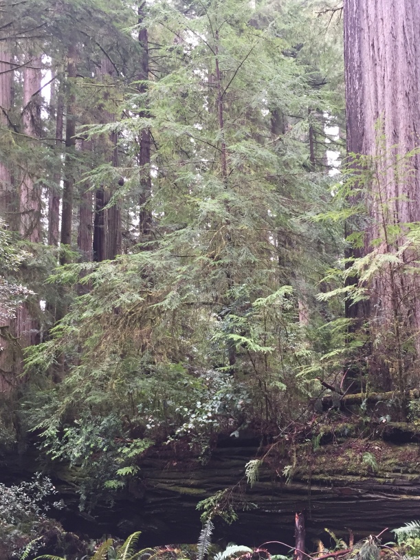
After leaving Lassen Volcanic NP (HERE and HERE) I took a scenic drive to the tippy top of CA with plans to make my way down.  There is no easy, direct way over.  Huge expanses of wilderness area, not accessible by vehicle, force one way up into Oregon (then back down) or along the curvy path of the Klamath River.

I chose the Klamath.  Though only 150 and some odd miles, I bet it took 4 hours to drive.  They were gorgeous, though, and worth every minute, especially nearly-in-Oregon vistas such as this:


++++++++++++++++++++++++++++++++++++++++++++++++++++++++

First real stop was in Crescent City, a town of 7,700 folks.  The wettest spot in CA it receives 70+” of rain yearly.  That’s 70.  7-0.  Gray/fog and a slight mist greeted me.

The city’s history is riddled with Tsunamis and one source told me 17 hit the shore from 1943-1994 though most were imperceptible.  1964 excepted that rule, though.

The Good Friday earthquake in Anchorage, AK sent waves down the coast, in just 4.5 hours, that wrecked havoc on the little city that’s mostly harbor.  All in all, 60 total blocks were affected with 30 leveled.  There were 12 deaths and many missing with over 100 injured.

These days, the city has preparedness in mind.  A 7.0 quake 90 miles offshore triggered an evacuation in 2005 with most of the city out in 20 minutes.

I noted Tsunami Zone warning signs over much of this trip’s path.  Made me wonder…and feel vulnerable.


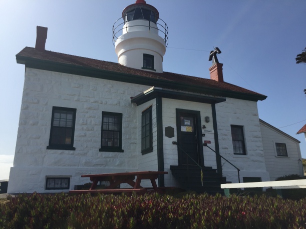
The starring attraction was the Battery Point Lighthouse.  A beauty she is!  Accessible only at low tide it’s perched on a little point surrounded by water (mostly). Now automated and  privately run,dedicated volunteers stay there 24/7 and give fascinating tours.


Looking into the harbor at the Jetty:


From a distance:


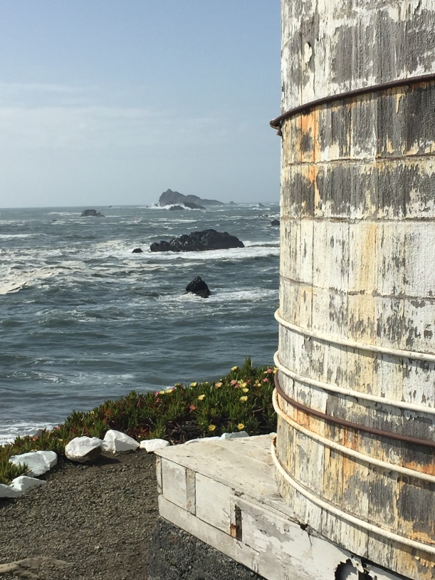
The Coolest part of the tour was getting to climb the stairs ALL the way up into the lens department to look out:


The view?  Fantastic.  Not sure I’ll ever get to go into a lighthouse’s uppermost compartment again.  It’s quite unheard of.  Note the downward pointed angles on the chimney to keep ocean water out.  It gets wild out there.


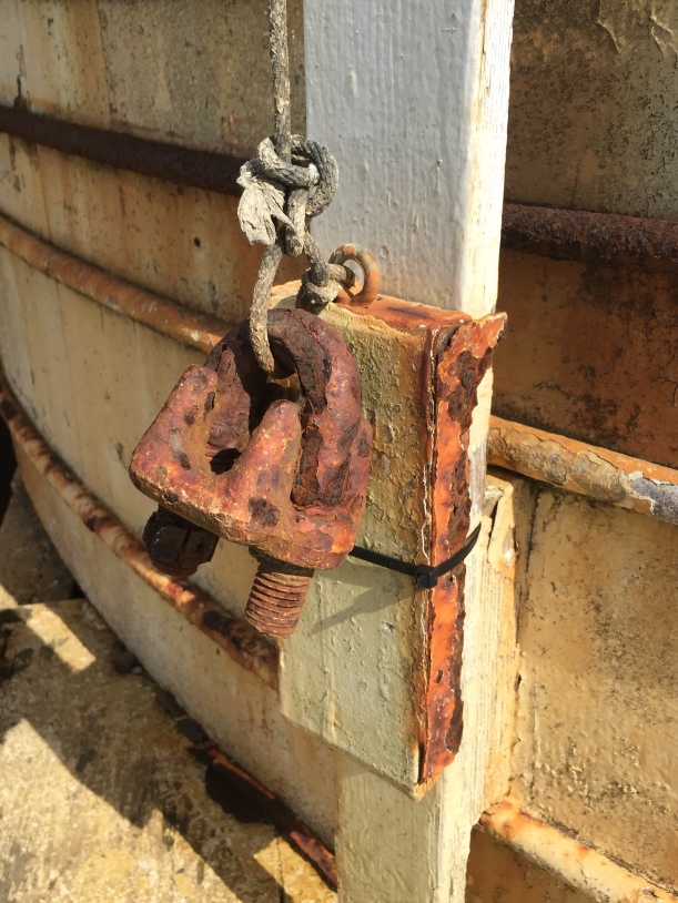
“Trash.” According to one volunteer.  Fun and quirky in my eyes:


Of note, there’s an old, out of commission lighthouse up the shore.  Photos I’ve perused are dramatic and foreboding.  Standing alone, 6 miles off the shore, on a chunk of rock just 300 feet in diameter, perched on a 50 foot high foundation, the ST GEORGE REEF LIGHTHOUSE  became too dangerous for maintenance and the keepers living in the lighthouse (not in a separate structure, as usual).  It was decommissioned and replaced by an automated buoy (or “boobie,” as we used to call buoys at the beach when swimming as kids.)   Several died during construction, keepers suffered “mental breakdowns” and frequently transferred out, supplies came by boat, water frequently crashed over the foundation and one storm ‘s waves broke windows 150’ off the water.

All the photos I found were by private artists and I do not want to infringe on any copyright laws.  I encourage you to look at THIS LINK.  It will awe you.

Thankfully, in 1982 the decaying and abandoned lighthouse’s First Order Fresnel lens was dismantled, each piece of glass numbered and helicoptered out with the aid of the Coast Guard.   The lens now stands, reconstructed, in the little museum  in Crescent city.

Of note, trips are offered (though infrequently and, of course, weather permitting) to this spot via helicopter.

Ooooh I want to go.